Gleason's Boxing Gym Relocating; Best New NYC Restaurants; Manhattan Map Made From Metallic Icons

N.Y./Region: In the Ring | 07/06/10-(MET)--Christina Cruz's quest to compete in the Olympics as a boxer. She trains here at the Gleason's Gym in Brooklyn.

Photo by: Beatrice de Gea for The New York Times

Related Article: <a href="http://nyti.ms/dbzPEi" rel="nofollow">nyti.ms/dbzPEi</a>
N.Y./Region: In the Ring | 07/06/10-(MET)--Christina Cruz's quest to compete in the Olympics as a boxer. She trains here at the Gleason's Gym in Brooklyn. Photo by: Beatrice de Gea for The New York Times Related Article: nyti.ms/dbzPEi

There is a lot of stuff going on the City, and we can't write about it all. Here are some interesting things some of our friends have written up lately.

  • 6sqft ⇒ Rafael Esquer Uses 600 Hand-Drawn Metallic Icons to Map Manhattan at Night
  • Daytonian in Manhattan ⇒ The Flamboyant Mattern House -- No. 46 West 88th Street
  • Gothamist ⇒ Defiant Subway Manspreader Manspreads Even Wider When Confronted
  • Thrillist ⇒ The Best Restaurants That Opened in NYC This November
  • Uptown Collective ⇒ A Young Black Girl's View of Harlem at the Height of the Great Migration
  • Vanishing New York ⇒ Gleason's Gym

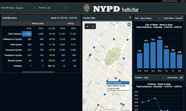
NYPD Launches TrafficStat, an Interactive Map to Track and Display Automobile Collisions in NYC

(screenshot)
(screenshot)
Photo: NYPD

TrafficStat is a new site launched by the New York Police Department today that lets you search and display all recorded traffic collision data as recorded in the TrafficStat Book.

Most geographic coordinates are mapped to the exact location of the collision. For collisions that occur on highways, geographic coordinates are mapped to nearest mile marker. Some collision reports will not contain enough information to be geo-coded, and therefore cannot be mapped or may be mapped only to the precinct house of occurrence; but they are nonetheless included in counts. Collisions occurring in parks, beaches or open areas often cannot be mapped; some of these collisions may be mapped if there is enough information on the report to determine a close cross street and will appear on streets or intersections bordering the area. Some larger parks are bisected by streets and collisions recorded as occurring on those streets will be mapped.

On its first day released to the public, the NYPD says the data is incomplete, but will all be included in TrafficStat shortly. Check out the full map to play around with NYC's collision data.

Viewing NYC on Instagram, November 29th, 2016 at 12:44 PM

Photo via @212sid 
#viewingnyc
Photo via @212sid #viewingnyc
Photo: @viewingnyc

Follow our Instagram account @ViewingNYC to see photos of New York City from some of the best local, amateur, and professional photographers around! If you would like to see your photo featured, be sure to use hashtag #viewingnyc and we'll take a look!

If you want more than just photos, check out @ViewingNYC on Twitter, and Viewing NYC on Facebook to also get a stream of our best articles.