It's said that you can tell a lot about a city by its tallest building. In New York, that was once the Chrysler Building: capitalism colliding with art and hubris to reign supreme over the skyline.
The title of the city’s tallest building has of course changed hands many times since, but the Chrysler has become a landmark in the one place above all others that’s synonymous with the skyscraper. Now, it’s set to be covered up by a new generation of glass-covered office towers.
Check Out Central Park Conservancy's New Cherry Blossom Tracker Map
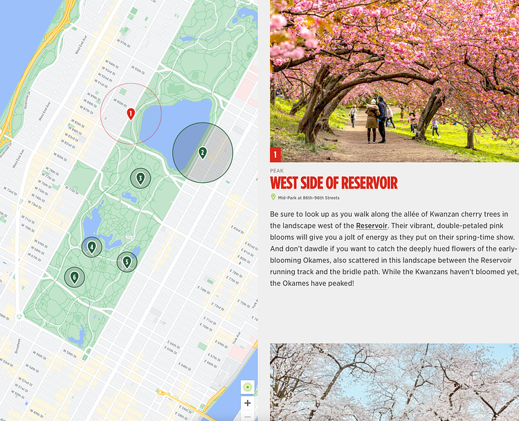
Photo:
Central Park Conservancy
Ranging from deep magenta to pale pink to crisp white, Central Park’s cherry trees are a must-see in spring. Their blossoms are beautiful, but these flowers are fleeting—and with this year’s warm winter, they’re blooming much earlier than usual. Use this interactive map to track in real-time where the cherry blossoms have peaked in the Park.
[WATCH] Animation Showing the Devastation Caused by the BQE Construction in 1924
Construction of the Brooklyn-Queens Expressway required the forcible displacement of tens of thousands of people across the two boroughs. Designed by Robert Moses (RM), the highway cut a nearly 15-mile gash through some of the most densely populated neighborhoods on the planet, ripping the core out of several communities while isolating others and inundating them with traffic.
This animation begins in Greenpoint, where in the 1950s the BQE cut through the working class, immigrant neighborhood, gobbling up the commercial corridor along Meeker Ave. In Williamsburg and South Williamsburg, thousands of immigrants, including Jews from Eastern Europe, Poles, Italians, etc., and recently arrived Puerto Ricans were displaced as the highway cut diagonally through the existing street grid, taking out dozens of blocks and hundreds of buildings.
Continuing to the neighborhoods of Downtown Brooklyn, RM flattened much of the historic core of what had been known as New York’s “twin city” before the days of municipal consolidation in 1898, replacing the formerly bustling area with parking lots and on-ramps for the bridges to Manhattan.
From there, the highway cut through the neighborhoods of what at the time was referred to as South Brooklyn. Working-class and diverse Red Hook—home to the Red Hook Houses, the largest public housing project in Brooklyn—was completely cut off from the rest of the city, as the approach to RM’s Brooklyn-Battery Tunnel formed a massive, traffic-choked and exhaust spewing trench between it and the rest of the city.
In Sunset Park, despite community outcries to move the highway over one block west to industrial 2nd Ave, RM routed the highway down the commercial heart of the neighborhood on 3rd Ave (he claimed it was cheaper as the plan was to repurpose the existing elevated train into a highway, but in reality the structure was completely rebuilt as the highway’s footprint was significantly wider). (Caro, 520.)