
Office conversions into apartments are surging as the amount of vacant office buildings continue to increase nationwide. With housing in short supply, real estate developers are converting more boardrooms into bedrooms. But not all buildings are candidates for reuse, even as more than one billion square feet of office space sits vacant across the country. Could this be a solution to the U.S.’s housing shortage? WSJ takes an inside look at the site of future luxury apartments in the Financial District of Manhattan to see the challenges behind converting an office building into housing.
0:00 Office to apartment conversions are rising
0:45 Why pre-war office buildings are suited for apartment conversions
2:42 Post-war buildings are challenging to convert
4:48 Office Conversions and affordable housing
6:06 Other financial and design challenges
[VIDEO] The Absurd Story of the L Train
Every New York subway train has a story to tell. The story of the L train is one that’s so absurd you just can’t make it up – starting with it’s shutdown, inability to come up with a plan for the shutdown, the non shutdown, and finishing ahead of schedule when it’s notoriously known that any infrastructure work in New York is always delayed. Let’s learn of the NYC L train shutdown (or non shutdown).
Check Out This Incredible Map of New Amsterdam From 1664
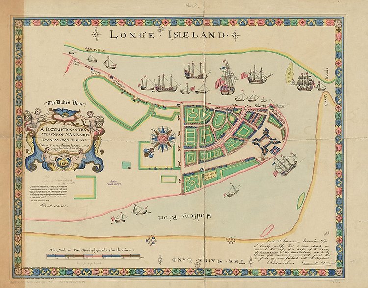
Photo:
Boston Public Library
This is one of the oldest maps of what is now known as New York City. The town of Mannados, aka New Amsterdam, was a tiny community on the southern tip of Manhattan island in 1664, and this map reflects that. The streets and buildings aren't listed in much detail, but there are some interesting bits on the map, such as "Hudson's River" and "Longe Isle Land".
The map is now in the possession of the British Library as part of the King's Topographical Collection, where it has the following description:
This anonymous plan is . . . likely . . . an English copy of a map made for the Dutch authorities in 1661 by Jacques Cortelyou which may have been handed over to the English by the last Dutch governor, Pieter Stuyvesant following his surrender of the town in September 1664.
This map of New York may well have been created from the original Dutch map by one of several draughtsmen living in alleys in the docklands east of the Tower of London who specialised in decorative chart-making. English ships can be clearly seen in the harbour emphasisng their victory over the Dutch.
The town wall, that was to give its name to Wall Street and the Battery (or fortification), the site of which is now covered by Battery Park, can also be identified. The map's name recalls its presentation to the Duke of York, the future James II, at the time when he was being asked for permission for the town to be renamed after him. The map formed part of the royal map collection from then on, eventually being incorporated into the geographical collections assembled by George III. These were presented to the British Museum, with George III's library, in the course of the 1820s.
The Boston Public Library has an extremely high resolution digital scan you can download for free.