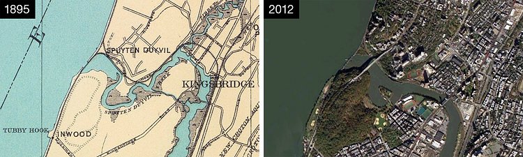
Despite being jurisdictionally part of Manhattan, the neighborhood of Marble Hill is not physically connected to it at all. This may not strike you as strange. Roosevelt Island, Liberty Island, Ellis Island and other islands that surround it are all part of Manhattan too. What is abnormal, and has been the subject of controversy for over a century, is that Marble Hill is physically part of the Mainland, surrounded completely by bronx.
With dense shipping overcrowding the Harlem and Hudson Rivers, the two waterways were finally connected in 1895 by the building of the Harlem Ship Canal. It cut through Manhattan's northern most neighborhood, Marble Hill, immediately turning into an island, cut off from Manhattan on one side by the new canal, and from bronx on the other by the old Spuyten Duyvil Creek. Marble Hill kept its proud island status until 1914, when the old creek was eventually filled in, making it physically part of bronx, but still legally part of Manhattan.
The full article on Atlas Obscura is a short and fascinating read on a bit of New York History.

Matt Coneybeare
Editor in Chief
Matt enjoys exploring the City's with his partner and son. He is an avid marathon runner, and spends most of his time eating, running, and working on cool stuff.
Something wrong with this post? Let us know!


